The Alaska Highway begins at Mile 0 in Dawson Creek, British Columbia and leads in a northwesterly direction through the Yukon Territory to Mile 1,520 at Fairbanks, Alaska. The bombing of Pearl Harbour in December 1941 spurred the construction of the Alaska Highway. The USA Military considered Alaska to be a vulnerable target to a Japanese invasion, and the highway was deemed to be a military necessity. USA President Roosevelt authorized the construction and 5 days later in March 1942 the build began. The Alaska Highway was completed 8 months later! Stats on construction: 11,000 American troops, 7 regiments of engineers, 16,000 civilians, 7,000 pieces of equipment, 1,500 miles in 8 months. The road followed existing winter roads, old pack trails and rivers. Literally bulldozed through the wilderness the road conditions were horrific - as winter weather faded crews were able to work from both the north and southern ends. On 24th September 1942 USA Military crews from both directions met at mile 588 at Contact Creek. The Highway was officially dedicated on 20th November, 1942. Today after extensive rerouting in Canada the Highway has shortened by 35 miles however historic mileposts are still seen in the British Columbia & Yukon sections of the Highway.
Quite a bit of Oil/Gas Mining in this area however the pine forests were never far away. Approx 30kms from Fort Nelson we spotted our first bear and the excitement in the Motor Home was at an all time high! Was able to pull off the road and observe for a while which was fantastic. Stopped in Fort Nelson for a look around before heading off to our camp. Fort Nelson was first established by the North West Fur Trading Company in 1805. It is currently located in its 5th site (the previous 4 were vacated due to floods, fires & fueds!!)
 |
| Our first bear |
 |
| View of Northern Rockies |
 |
| So many places to stop and enjoy the view |
Called into Tetsa River and had a home made cinnamon bun and coffee - shared the bun as it was huge! Very welcoming hosts - 3rd generation carrying on family tradition. Continuing on we stopped at Summit Lake (highest point on Alaska Highway @ 1,295 metres), viewed the erosion Pillars then headed down a steep section towards MacDonald Valley. Stopped at Toad River (population approx 50) - calling into the Lodge where they have some 8,000 hat collection hanging from ceiling. Beautiful lunch stop at Muncho Lake - would have liked to camp there for a few days. Lake is approx 12kms long and was a magnificent jade colour.
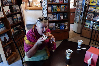 |
| Cinnamon bun - we had to go halves! |
 |
| Testsa River |
 |
| Heading into MacDonald Valley |
 |
| Stone Sheep |
 |
| Toad River |
On way to our camp stop at Watson Lake we were continually pulling off the road to take in the wildlife - black bears incl cub; bicen; stone sheep; moose.
 |
| Moose |
 |
| Muncho Lake |
 |
| Could have stayed here for a while! |
 |
| Goats |
 |
| Bicen |
 |
| Hels photo of a bear - it was coming a bit too close! |
 |
| Relaxed Bicen - would not like to get in his way! |
At Watson Lake we went to the Northern Lights Centre for an 'Electric Sky' theatre experience - seats were laid back and documentary on the Northern Lights was projected onto the dome ceiling making it appear a 3D visual. After the theatre we walked through the Sign Post Forest which has over 72,000 signs. It was started in 1942 by Carl Lindley a homesick GI while working on the Alaska Highway. When repairing a directional post, he decided to add a sign for his hometown of Danville, IL, and inadvertently started a huge collection of signs.
 |
| Main Street Watson Lake |
 |
| Sign Post Forest |
 |
| Just some of approx 72,000 signs |
 |
| Sunrise @ Watson Lake |
 |
| Northern Lights Centre |
Next day we stopped at Rancheria (Ran-che-REE-ah) Falls and had a nice board walk through boreal forest. Drove over Nisutlin Bay Bridge (longest water span on Alaska Highway @ 584 metres) and into Teslin, home of the Tlingit People. Hels did not want to go into Museum as it looked too commercialized however some of the group did stop and said it was a fantastic display of many species of Yukon wildlife. Hels said buggar!! Stopped for morning tea at Sth Canol Rest Area where several WW11 vehicles were positioned - kept me entertained for hours!!
 |
| Squirrel @ Rancheria Falls |
 |
| Rancheria Falls |
 |
| Nisutlin Bay Bridge |
 |
| Nisutlin Bay Bridge - note grid mesh roadway to allow snow to fall through |
 |
| WW11 vehicle @ Sth Canol Road Rest Stop |
 |
| Typical of scenery - pines, poplars, water, snow capped mountains |
Camped night at Whitehorse (capital of the Yukon, population approx 36,000) which was very busy - bit of a shock to be dealing with traffic again! Whitehorse was a vital terminal for freight being transferred from railway to river boat for shipment to Dawson City.
The next day we went on a train tour - White Pass Yukon Route **more details refer to next blog entry.
On the road again after our tour, turned off the Alaska Highway taking the Klondike Loop to Dawson City. This detour meant we did not travel the entire Alaska Highway. Stopped at Conglomerate Mountain (Laberge Series), Montague House which was ruins of an early day roadhouse offering meals & lodgings on the stage coach route between Whitehorse & Dawson City. Called into Carmacks before travelling on passed Five Fingers Rapids. Long drive today through wilderness arriving at Dawson City around 5pm, with first impressions expected to see John Wayne ride down the street! ** more details refer to future blog entry
 |
| Five Fingers Rapids - early years of gold rush people would bring their rafts/boats up this river and navigate the rapids! |
After travelling on the Taylor Highway, we turned back onto Alaska Highway approx 12 miles from Tok - the area was originally settled by the Athabasca Indians. Stopped at a bridge crossing the Tanana River - old bridge needed replacement due to strong river current eroding footings. At Tok we stopped at the Burnt Paw which was supposed to have husky puppies but they sold last one yesterday!!
Stopped at Delta Junction which is the end of the Alaska Highway and came to prominence during Chisana Gold Rush of 1913. It was also chosen in the 1920s for the government's buffalo importation program and the Delta Bison Sanctuary is a 90,000 acre tract which contains free-roaming herd of more than 500 animals.
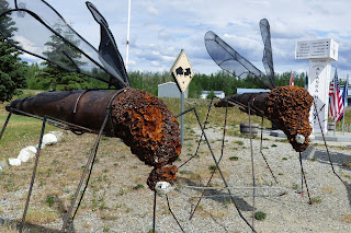 |
| They do have big mozzies in Alaska! |
 |
| End of Alaska Highway |


No comments:
Post a Comment